
Bouillon topographic map
Interactive map
Click on the map to display elevation.
About this map
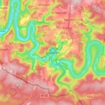
Name: Bouillon topographic map, elevation, terrain.
Location: Bouillon, Neufchâteau, Luxembourg, Wallonie, 6830, Belgique (49.75498 5.02725 49.83498 5.10725)
Average elevation: 1,109 ft
Minimum elevation: 640 ft
Maximum elevation: 1,467 ft
Entourée de forêts, la ville s’étend dans et autour d’un méandre accentué de la Semois, un affluent de la Meuse. L'altitude y est d'environ 220 mètres. Elle est desservie par la route nationale 83 menant à Arlon, route qui borde la ville à l’est et qui se confond sur le territoire communal avec la route européenne 46 reliant Cherbourg (France) et Liège. La frontière française se trouve à moins de cinq kilomètres à l’ouest et au sud.
Other topographic maps
Click on a map to view its topography, its elevation and its terrain.
Corbion
Belgique > Luxembourg > Neufchâteau > Bouillon
Corbion, Bouillon, Neufchâteau, Luxembourg, Wallonie, 6838, Belgique
Average elevation: 1,129 ft
Le Tombeau du Géant
Belgique > Luxembourg > Neufchâteau > Bouillon > Ucimont > Botassart
Le Tombeau du Géant, Moulin du Rivage, Botassart, Ucimont, Bouillon, Neufchâteau, Luxembourg, Wallonie, 6833, Belgique
Average elevation: 984 ft
Sensenruth
Belgique > Luxembourg > Neufchâteau > Bouillon
Sensenruth, Bouillon, Neufchâteau, Luxembourg, Wallonie, 6832, Belgique
Average elevation: 1,175 ft
Frahan
Belgique > Luxembourg > Neufchâteau > Bouillon > Rochehaut
Frahan, Rochehaut, Bouillon, Neufchâteau, Luxembourg, Wallonie, 6838, Belgique
Average elevation: 955 ft
Rochehaut
Belgique > Luxembourg > Neufchâteau > Bouillon
Rochehaut, Bouillon, Neufchâteau, Luxembourg, Wallonie, Belgique
Average elevation: 971 ft
Dohan
Belgique > Luxembourg > Neufchâteau > Bouillon
Dohan, Bouillon, Neufchâteau, Luxembourg, Wallonie, Belgique
Average elevation: 932 ft
Cordemois
Belgique > Luxembourg > Neufchâteau > Bouillon
Cordemois, Bouillon, Neufchâteau, Luxembourg, Wallonie, 6830, Belgique
Average elevation: 1,024 ft
Curfoz
Belgique > Luxembourg > Neufchâteau > Bouillon
Curfoz, Bouillon, Neufchâteau, Luxembourg, Wallonie, 6831, Belgique
Average elevation: 1,129 ft
Briahan
Belgique > Luxembourg > Neufchâteau > Bouillon
Briahan, Sensenruth, Bouillon, Neufchâteau, Luxembourg, Wallonie, 6832, Belgique
Average elevation: 1,191 ft