
Frog Hollow topographic map
Interactive map
Click on the map to display elevation.
About this map
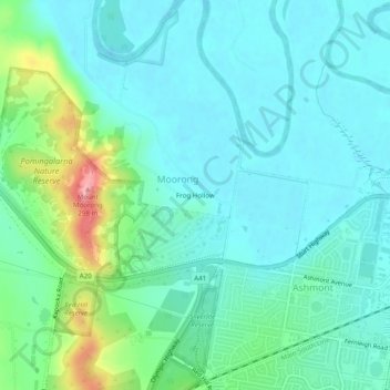
Name: Frog Hollow topographic map, elevation, terrain.
Average elevation: 653 ft
Minimum elevation: 564 ft
Maximum elevation: 971 ft
Other topographic maps
Click on a map to view its topography, its elevation and its terrain.
Tolland
Australia > New South Wales > Frog Hollow
Tolland, Frog Hollow, Wagga Wagga City Council, New South Wales, 2650, Australia
Average elevation: 748 ft
Turvey Park
Australia > New South Wales > Frog Hollow
Turvey Park, Frog Hollow, Wagga Wagga City Council, New South Wales, 2650, Australia
Average elevation: 689 ft