Geolocate

Real topographic map

Click on the map to display elevation.

About this map

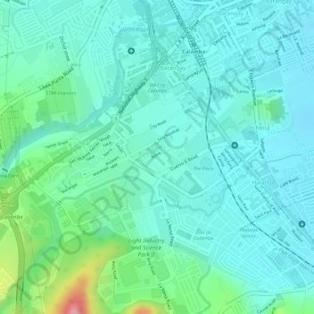
Name: Real topographic map, elevation, terrain.

Location: Real, Calamba, Laguna, Calabarzon, 4027, Philippines (14.18622 121.14002 14.20840 121.16118)

Average elevation: 138 ft

Minimum elevation: 39 ft

Maximum elevation: 427 ft

Other topographic maps

Click on a map to view its topography, its elevation and its terrain.

Bucal

Philippines > Laguna > Calamba

Average elevation: 72 ft

88 Spa & Resort

Philippines > Laguna > Calamba

Average elevation: 272 ft

ASN Ph2 Park

Philippines > Laguna > Calamba

Average elevation: 436 ft

Bucal Reservoir

Philippines > Laguna > Calamba

Average elevation: 138 ft

Calamba Town Plaza

Philippines > Laguna > Calamba

Average elevation: 36 ft

Gear up for your next adventure:

🛠️Outdoor Gear Repair Kit - Essential tools to fix gear on the trail
🪶Trail Camera - Capture wildlife on your hikes
🧥Men's Rain Shells - Premium waterproof and breathable jackets for mountain weather
🪶Paracord Bracelet - Survival bracelet with built‑in tools
📖Nature Tracking Books - Learn to track wildlife and terrain

As an Amazon Associate, this site earns from qualifying purchases at no extra cost to you.