
Make a donation
Gear up for your next adventure:
As an Amazon Associate, this site earns from qualifying purchases at no extra cost to you.
Bydgoszcz topographic map
Click on the map to display elevation.
Make a donation
Gear up for your next adventure:
As an Amazon Associate, this site earns from qualifying purchases at no extra cost to you.
Bydgoszcz
The etymology of the German name of the town developed later and derives from the river Brahe (Brda in Polish), on banks of which the place sits, and berg, elevation, mount(ain), combined to 'Brahenberg', with 'a' pronounced in East Pomeranian Low German rather like 'å', later contracted to Bromberg, dropping the weak 'h', with the 'n' assimilated as 'm' to the following labial sound 'b'.
Make a donation
Gear up for your next adventure:
As an Amazon Associate, this site earns from qualifying purchases at no extra cost to you.
About this map
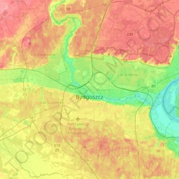
Name: Bydgoszcz topographic map, elevation, terrain.
Location: Bydgoszcz, Kuyavian-Pomeranian Voivodeship, Poland (53.05011 17.87417 53.20934 18.20259)
Average elevation: 233 ft
Minimum elevation: 85 ft
Maximum elevation: 371 ft
Make a donation
Gear up for your next adventure:
As an Amazon Associate, this site earns from qualifying purchases at no extra cost to you.
Other topographic maps
Click on a map to view its topography, its elevation and its terrain.
Kowrózek
Poland > Kuyavian-Pomeranian Voivodeship > Toruń County > Świerczyny
Average elevation: 279 ft
Make a donation
Gear up for your next adventure:
As an Amazon Associate, this site earns from qualifying purchases at no extra cost to you.
Make a donation
Gear up for your next adventure:
As an Amazon Associate, this site earns from qualifying purchases at no extra cost to you.
Make a donation
Gear up for your next adventure:
As an Amazon Associate, this site earns from qualifying purchases at no extra cost to you.
Make a donation
Gear up for your next adventure:
As an Amazon Associate, this site earns from qualifying purchases at no extra cost to you.
Make a donation
Gear up for your next adventure:
As an Amazon Associate, this site earns from qualifying purchases at no extra cost to you.
Make a donation
Gear up for your next adventure:
As an Amazon Associate, this site earns from qualifying purchases at no extra cost to you.
Huby
Poland > Kuyavian-Pomeranian Voivodeship > Tuchola County > Mały Mędromierz
Average elevation: 459 ft
Make a donation
Gear up for your next adventure:
As an Amazon Associate, this site earns from qualifying purchases at no extra cost to you.