
Bangkok topographic map
Interactive map
Click on the map to display elevation.
About this map
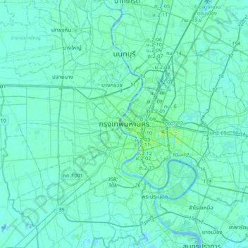
Name: Bangkok topographic map, elevation, terrain.
Location: Bangkok, 10200, Thailand (13.59249 100.33351 13.91249 100.65351)
Average elevation: 13 ft
Minimum elevation: -52 ft
Maximum elevation: 138 ft
Bangkok is situated in the Chao Phraya River delta in Thailand's central plain. The river meanders through the city in a southerly direction, emptying into the Gulf of Thailand approximately 25 kilometres (16 mi) south of city centre. The area is flat and low-lying, with an average elevation of 1.5 metres (4 ft 11 in) above sea level. Most of the area was originally swampland, which was gradually drained and irrigated for agriculture by the construction of canals (khlong) which took place from the 16th to 19th centuries. The course of the river as it flows through Bangkok has been modified by the construction of several shortcut canals.
Other topographic maps
Click on a map to view its topography, its elevation and its terrain.
Phra Khanong District
Phra Khanong District, Bangkok, 10260, Thailand
Average elevation: 13 ft
Khlong Toei District
Khlong Toei District, Bangkok, Thailand
Average elevation: 23 ft
Bang Kho Laem District
Bang Kho Laem District, Bangkok, 10120, Thailand
Average elevation: 20 ft
Lat Krabang District
Lat Krabang District, Bangkok, 10520, Thailand
Average elevation: 10 ft
Bang Rak District
Bang Rak District, Bangkok, 10500, Thailand
Average elevation: 26 ft
Khlong Sam Wa District
Khlong Sam Wa District, Bangkok, 10510, Thailand
Average elevation: 13 ft
Khlong Tan Nuea Subdistrict
Thailand > Bangkok > Khlong Tan Nuea Subdistrict
Khlong Tan Nuea Subdistrict, Watthana District, Bangkok, 10110, Thailand
Average elevation: 20 ft
Lat Yao Subdistrict
Thailand > Bangkok > Lat Yao Subdistrict
Lat Yao Subdistrict, Chatuchak District, Bangkok, 10900, Thailand
Average elevation: 16 ft
Thanon Nakhon Chai Si Subdistrict
Thailand > Bangkok > Thanon Nakhon Chai Si Subdistrict
Thanon Nakhon Chai Si Subdistrict, Dusit District, Bangkok, 10300, Thailand
Average elevation: 20 ft
Lumphini Subdistrict
Thailand > Bangkok > Lumphini Subdistrict
Lumphini Subdistrict, Pathum Wan District, Bangkok, 10330, Thailand
Average elevation: 30 ft
Arokaya Park, 77th Anniversary of Kasetsart University
Arokaya Park, 77th Anniversary of Kasetsart University, Kaset, Bangkok, Chatuchak District, Bangkok, 10900, Thailand
Average elevation: 16 ft
Chom Thong District
Chom Thong District, Bangkok, 10150, Thailand
Average elevation: 16 ft