
Make a donation
Gear up for your next adventure:
As an Amazon Associate, this site earns from qualifying purchases at no extra cost to you.
Khlong Sam Wa District topographic map
Click on the map to display elevation.
Make a donation
Gear up for your next adventure:
As an Amazon Associate, this site earns from qualifying purchases at no extra cost to you.
About this map
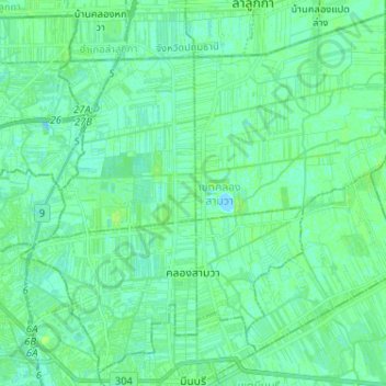
Name: Khlong Sam Wa District topographic map, elevation, terrain.
Location: Khlong Sam Wa District, Bangkok, 10510, Thailand (13.81544 100.67080 13.93156 100.79937)
Average elevation: 13 ft
Minimum elevation: -7 ft
Maximum elevation: 26 ft
Make a donation
Gear up for your next adventure:
As an Amazon Associate, this site earns from qualifying purchases at no extra cost to you.
Other topographic maps
Click on a map to view its topography, its elevation and its terrain.
Bangkok
Bangkok is situated in the Chao Phraya River delta in Thailand's central plain. The river meanders through the city in a southerly direction, emptying into the Gulf of Thailand approximately 25 kilometres (16 mi) south of city centre. The area is flat and low-lying, with an average elevation of 1.5 metres (4…
Average elevation: 13 ft