
Lecina topographic map
Interactive map
Click on the map to display elevation.
About this map
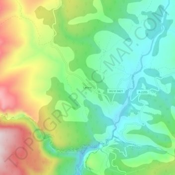
Name: Lecina topographic map, elevation, terrain.
Location: Lecina, Bárcabo, Sobrarbe, Huesca, Aragon, 22148, Espagne (42.20979 0.01500 42.24979 0.05500)
Average elevation: 2,641 ft
Minimum elevation: 2,073 ft
Maximum elevation: 3,675 ft
Other topographic maps
Click on a map to view its topography, its elevation and its terrain.
Santa María de la Nuez
Espagne > Aragon > Sobrarbe > Bárcabo
Santa María de la Nuez, Bárcabo, Sobrarbe, Huesca, Aragon, 22149, Espagne
Average elevation: 3,120 ft