
Chemini topographic map
Interactive map
Click on the map to display elevation.
About this map
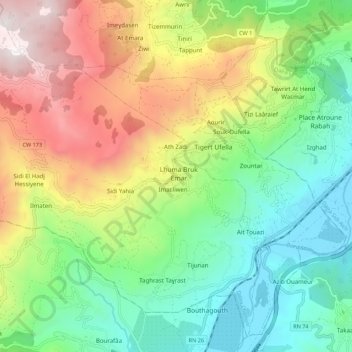
Name: Chemini topographic map, elevation, terrain.
Location: Chemini, Daïra Chemini, Béjaïa, 06770, Algérie (36.55408 4.53919 36.63444 4.64885)
Average elevation: 2,162 ft
Minimum elevation: 295 ft
Maximum elevation: 5,302 ft
La commune est située à une altitude moyenne de 800 mètres.
Other topographic maps
Click on a map to view its topography, its elevation and its terrain.
Izerouken
Algérie > Béjaïa > Daïra Chemini > Tiliouacadi
Izerouken, Tiliouacadi, Souk Oufella, Daïra Chemini, Béjaïa, 06042, Algérie
Average elevation: 2,195 ft