
Le Perreux topographic map
Interactive map
Click on the map to display elevation.
About this map
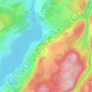
Name: Le Perreux topographic map, elevation, terrain.
Average elevation: 3,146 ft
Minimum elevation: 2,776 ft
Maximum elevation: 3,652 ft
Other topographic maps
Click on a map to view its topography, its elevation and its terrain.
Chaon
France > Bourgogne-Franche-Comté > Doubs > Montperreux
Chaon, Montperreux, Pontarlier, Doubs, Bourgogne-Franche-Comté, France métropolitaine, 25160, France
Average elevation: 3,120 ft
Beau Site
France > Bourgogne-Franche-Comté > Doubs > Montperreux
Beau Site, Montperreux, Pontarlier, Doubs, Bourgogne-Franche-Comté, France métropolitaine, 25160, France
Average elevation: 3,159 ft
La Cotelle
France > Bourgogne-Franche-Comté > Doubs > Montperreux
La Cotelle, Montperreux, Pontarlier, Doubs, Bourgogne-Franche-Comté, France métropolitaine, 25160, France
Average elevation: 3,130 ft