
Byawatha topographic map
Interactive map
Click on the map to display elevation.
About this map
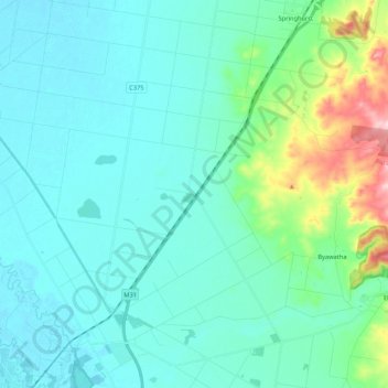
Name: Byawatha topographic map, elevation, terrain.
Average elevation: 597 ft
Minimum elevation: 456 ft
Maximum elevation: 1,322 ft
Other topographic maps
Click on a map to view its topography, its elevation and its terrain.
Wangaratta
Australia > Victoria > Wangaratta
Wangaratta, Rural City of Wangaratta, Hume, Victoria, 3676, Australia
Average elevation: 617 ft
Warby-Ovens National Park
Australia > Victoria > Wangaratta > Glenrowan
Warby-Ovens National Park, Glenrowan, Rural City of Benalla, Victoria, Australia
Average elevation: 561 ft
Byawatha
Australia > Victoria > Wangaratta > Byawatha
Byawatha, Wangaratta, Rural City of Wangaratta, Victoria, 3746, Australia
Average elevation: 709 ft
Wangandary
Australia > Victoria > Wangaratta > Wanganderry Creek
Wangandary, Wangaratta, Rural City of Wangaratta, Victoria, Australia
Average elevation: 827 ft