
Make a donation
Gear up for your next adventure:
As an Amazon Associate, this site earns from qualifying purchases at no extra cost to you.
Monchique topographic map
Click on the map to display elevation.
Make a donation
Gear up for your next adventure:
As an Amazon Associate, this site earns from qualifying purchases at no extra cost to you.
Monchique
Monchique has a Mediterranean climate with warm to hot summers and mild, wet winters. Due to its altitude and location, right between the valley formed by the Serra de Monchique, precipitation in the winter is much larger than anywhere else on the Algarve. Its position on the southwest corner of Portugal gives it very mild temperatures in the winter, especially for its altitude.
Make a donation
Gear up for your next adventure:
As an Amazon Associate, this site earns from qualifying purchases at no extra cost to you.
About this map
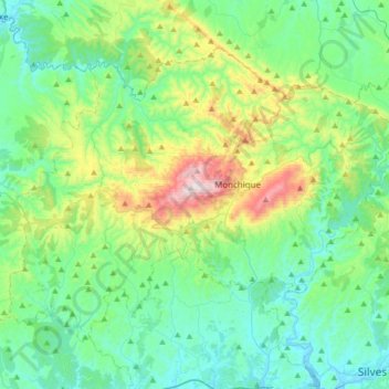
Name: Monchique topographic map, elevation, terrain.
Location: Monchique, Faro, Portugal (37.20982 -8.75513 37.41198 -8.41998)
Average elevation: 676 ft
Minimum elevation: -7 ft
Maximum elevation: 2,933 ft
Make a donation
Gear up for your next adventure:
As an Amazon Associate, this site earns from qualifying purchases at no extra cost to you.
Other topographic maps
Click on a map to view its topography, its elevation and its terrain.
Make a donation
Gear up for your next adventure:
As an Amazon Associate, this site earns from qualifying purchases at no extra cost to you.