
Eravikulam National Park topographic map
Interactive map
Click on the map to display elevation.
About this map
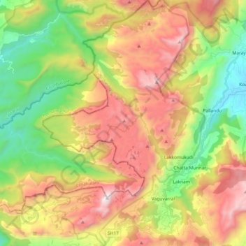
Name: Eravikulam National Park topographic map, elevation, terrain.
Average elevation: 5,591 ft
Minimum elevation: 2,933 ft
Maximum elevation: 8,806 ft
Other topographic maps
Click on a map to view its topography, its elevation and its terrain.
Anamudi
India > Kerala > Kothamangalam > Idukki
Anamudi, Idukki, Kothamangalam, Ernakulam district, Kerala, 685614, India
Average elevation: 7,247 ft