
Frankenhain topographic map
Interactive map
Click on the map to display elevation.
About this map
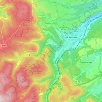
Name: Frankenhain topographic map, elevation, terrain.
Location: Frankenhain, Geratal, Ilm-Kreis, Thüringen, Deutschland (50.70683 10.75097 50.76995 10.81572)
Average elevation: 1,850 ft
Minimum elevation: 1,211 ft
Maximum elevation: 2,628 ft
Other topographic maps
Click on a map to view its topography, its elevation and its terrain.
Talsperre Lütsche
Deutschland > Thüringen > Ilm-Kreis > Frankenhain
Talsperre Lütsche, Frankenhain, Geratal, Ilm-Kreis, Thüringen, 99330, Deutschland
Average elevation: 2,152 ft