
Thank you for supporting this site ❤️
Make a donation
Make a donation
Gear up for your next adventure:
As an Amazon Associate, this site earns from qualifying purchases at no extra cost to you.
Cholula topographic map
Click on the map to display elevation.
Thank you for supporting this site ❤️
Make a donation
Make a donation
Gear up for your next adventure:
As an Amazon Associate, this site earns from qualifying purchases at no extra cost to you.
About this map
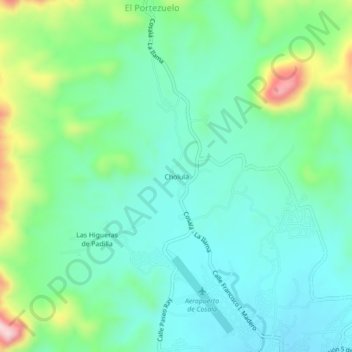
Name: Cholula topographic map, elevation, terrain.
Location: Cholula, Cosalá, Sinaloa, 80700, Mexico (24.41381 -106.72240 24.45381 -106.68240)
Average elevation: 1,506 ft
Minimum elevation: 1,237 ft
Maximum elevation: 2,267 ft
Thank you for supporting this site ❤️
Make a donation
Make a donation
Gear up for your next adventure:
As an Amazon Associate, this site earns from qualifying purchases at no extra cost to you.