
La Mosson (bras) topographic map
Interactive map
Click on the map to display elevation.
About this map
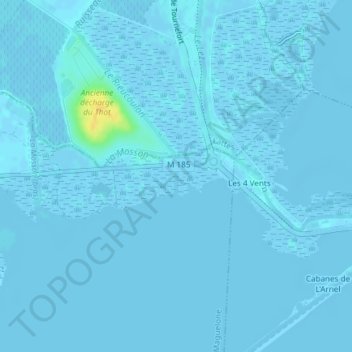
Name: La Mosson (bras) topographic map, elevation, terrain.
Average elevation: 0 ft
Minimum elevation: -13 ft
Maximum elevation: 75 ft
Other topographic maps
Click on a map to view its topography, its elevation and its terrain.
L'Esclavon
France > Occitanie > Hérault > Villeneuve-lès-Maguelone
L'Esclavon, Villeneuve-lès-Maguelone, Montpellier, Hérault, Occitanie, France métropolitaine, 34750, France
Average elevation: -3 ft
Les Salins
France > Occitanie > Hérault > Villeneuve-lès-Maguelone
Les Salins, Villeneuve-lès-Maguelone, Montpellier, Hérault, Occitanie, France métropolitaine, 34750, France
Average elevation: 3 ft