
Make a donation
Gear up for your next adventure:
As an Amazon Associate, this site earns from qualifying purchases at no extra cost to you.
Mzamba River topographic map
Click on the map to display elevation.
Make a donation
Gear up for your next adventure:
As an Amazon Associate, this site earns from qualifying purchases at no extra cost to you.
About this map
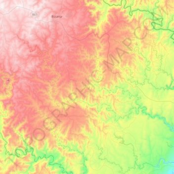
Name: Mzamba River topographic map, elevation, terrain.
Average elevation: 1,811 ft
Minimum elevation: 302 ft
Maximum elevation: 3,412 ft
Make a donation
Gear up for your next adventure:
As an Amazon Associate, this site earns from qualifying purchases at no extra cost to you.
Other topographic maps
Click on a map to view its topography, its elevation and its terrain.
Bizana
South Africa > Eastern Cape > Alfred Nzo District Municipality > Mbizana Local Municipality
Average elevation: 2,700 ft
Matatiele
South Africa > Eastern Cape > Alfred Nzo District Municipality > Matatiele Local Municipality
Average elevation: 5,259 ft
eMaXesibeni (Mount Ayliff)
South Africa > Eastern Cape > Alfred Nzo District Municipality > Umzimvubu Local Municipality
Average elevation: 3,701 ft
Mbizana Local Municipality
South Africa > Eastern Cape > Alfred Nzo District Municipality
Average elevation: 2,083 ft
Make a donation
Gear up for your next adventure:
As an Amazon Associate, this site earns from qualifying purchases at no extra cost to you.
KwaBhaca (Mount Frere)
South Africa > Eastern Cape > Alfred Nzo District Municipality > Umzimvubu Local Municipality
Average elevation: 3,661 ft
Matatiele Local Municipality
South Africa > Eastern Cape > Alfred Nzo District Municipality
Average elevation: 5,640 ft
Matatiele
South Africa > Eastern Cape > Alfred Nzo District Municipality > Matatiele Local Municipality
Average elevation: 5,259 ft
KwaBhaca (Mount Frere)
South Africa > Eastern Cape > Alfred Nzo District Municipality > Umzimvubu Local Municipality
Average elevation: 3,661 ft
Make a donation
Gear up for your next adventure:
As an Amazon Associate, this site earns from qualifying purchases at no extra cost to you.
KwaBhaca (Mount Frere)
South Africa > Eastern Cape > Alfred Nzo District Municipality > Umzimvubu Local Municipality
Average elevation: 3,661 ft
eMaXesibeni (Mount Ayliff)
South Africa > Eastern Cape > Alfred Nzo District Municipality > Umzimvubu Local Municipality
Average elevation: 3,701 ft
Matatiele Local Municipality
South Africa > Eastern Cape > Alfred Nzo District Municipality
Average elevation: 5,640 ft
Umzimvubu Local Municipality
South Africa > Eastern Cape > Alfred Nzo District Municipality
Average elevation: 4,117 ft
Make a donation
Gear up for your next adventure:
As an Amazon Associate, this site earns from qualifying purchases at no extra cost to you.
eMaXesibeni (Mount Ayliff)
South Africa > Eastern Cape > Alfred Nzo District Municipality > Umzimvubu Local Municipality
Average elevation: 3,701 ft
Tabankulu
South Africa > Eastern Cape > Alfred Nzo District Municipality > Ntabankulu Local Municipality
Average elevation: 3,645 ft
Bizana
South Africa > Eastern Cape > Alfred Nzo District Municipality > Mbizana Local Municipality
Average elevation: 2,700 ft
eMaXesibeni (Mount Ayliff)
South Africa > Eastern Cape > Alfred Nzo District Municipality > Umzimvubu Local Municipality
Average elevation: 3,701 ft
Make a donation
Gear up for your next adventure:
As an Amazon Associate, this site earns from qualifying purchases at no extra cost to you.
Cedarville
South Africa > Eastern Cape > Alfred Nzo District Municipality > Matatiele Local Municipality
Average elevation: 4,905 ft
Mbizana Local Municipality
South Africa > Eastern Cape > Alfred Nzo District Municipality
Average elevation: 2,083 ft
Bizana
South Africa > Eastern Cape > Alfred Nzo District Municipality > Mbizana Local Municipality
Average elevation: 2,700 ft
Matatiele
South Africa > Eastern Cape > Alfred Nzo District Municipality > Matatiele Local Municipality
Average elevation: 5,259 ft
Make a donation
Gear up for your next adventure:
As an Amazon Associate, this site earns from qualifying purchases at no extra cost to you.
Matatiele Local Municipality
South Africa > Eastern Cape > Alfred Nzo District Municipality
Average elevation: 5,640 ft