
Make a donation
Gear up for your next adventure:
As an Amazon Associate, this site earns from qualifying purchases at no extra cost to you.
El Centinela topographic map
Click on the map to display elevation.
Make a donation
Gear up for your next adventure:
As an Amazon Associate, this site earns from qualifying purchases at no extra cost to you.
About this map
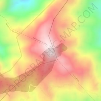
Name: El Centinela topographic map, elevation, terrain.
Average elevation: 7,822 ft
Minimum elevation: 6,778 ft
Maximum elevation: 8,455 ft
Make a donation
Gear up for your next adventure:
As an Amazon Associate, this site earns from qualifying purchases at no extra cost to you.
Other topographic maps
Click on a map to view its topography, its elevation and its terrain.
Santo Domingo de los Tsachilas
Ecuador > Santo Domingo de los Tsáchilas > Santo Domingo
Santo Domingo is located approximately 133 km west of Quito at an elevation of 625 metres or 2,051 feet. Santo Domingo lies in the foothills west of the Andes. It is important stopping point on the road from Quito to the Pacific coast. The city also connects other lowland cities like Quevedo, Chone, and…
Average elevation: 2,280 ft