
Make a donation
Gear up for your next adventure:
As an Amazon Associate, this site earns from qualifying purchases at no extra cost to you.
Varese topographic map
Click on the map to display elevation.
Make a donation
Gear up for your next adventure:
As an Amazon Associate, this site earns from qualifying purchases at no extra cost to you.
About this map
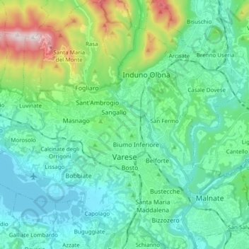
Name: Varese topographic map, elevation, terrain.
Location: Varese, Lombardy, Italy (45.77855 8.73695 45.88387 8.86995)
Average elevation: 1,437 ft
Minimum elevation: 768 ft
Maximum elevation: 3,953 ft
Make a donation
Gear up for your next adventure:
As an Amazon Associate, this site earns from qualifying purchases at no extra cost to you.
Other topographic maps
Click on a map to view its topography, its elevation and its terrain.
Pianca
Italy > Lombardy > Varese > Maccagno con Pino e Veddasca > Maccagno Superiore
Average elevation: 1,194 ft
Parco archeologico di Castel Seprio
Italy > Lombardy > Varese > Castelseprio > Vico Seprio
Average elevation: 1,030 ft
Make a donation
Gear up for your next adventure:
As an Amazon Associate, this site earns from qualifying purchases at no extra cost to you.