
Cristóbal topographic map
Interactive map
Click on the map to display elevation.
About this map
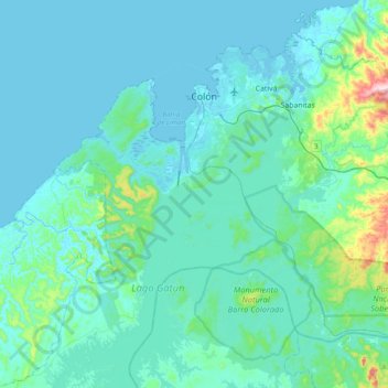
Name: Cristóbal topographic map, elevation, terrain.
Location: Cristóbal, Distrito Colón, Colón, Panamá (9.11119 -80.04493 9.40565 -79.65618)
Average elevation: 151 ft
Minimum elevation: -7 ft
Maximum elevation: 1,437 ft
Other topographic maps
Click on a map to view its topography, its elevation and its terrain.
Esclusas de Gatún
Panamá > Colón > Distrito Colón > Cristóbal > Gatún
Esclusas de Gatún, Gatún, Cristóbal, Distrito Colón, Colón, Panamá
Average elevation: 56 ft
Isla Mina
Panamá > Colón > Distrito Colón > Cristóbal
Isla Mina, Cristóbal, Distrito Colón, Colón, Panamá
Average elevation: 10 ft