
Okemos topographic map
Click on the map to display elevation.
About this map
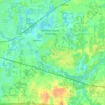
Name: Okemos topographic map, elevation, terrain.
Location: Okemos, Ingham County, Michigan, 48864, United States (42.68283 -84.46213 42.74448 -84.36339)
Average elevation: 866 ft
Minimum elevation: 827 ft
Maximum elevation: 938 ft
Ingham County trails, hiking, mountain biking, running and outdoor activities
Other topographic maps
Click on a map to view its topography, its elevation and its terrain.
Burchfield Park
United States > Michigan > Ingham County > Delhi Charter Township
Average elevation: 879 ft
Village of Dansville Community Park
United States > Michigan > Ingham County > Dansville
Average elevation: 948 ft