
Thank you for supporting this site ❤️
Make a donation
Make a donation
Gear up for your next adventure:
As an Amazon Associate, this site earns from qualifying purchases at no extra cost to you.
Juf topographic map
Click on the map to display elevation.
Thank you for supporting this site ❤️
Make a donation
Make a donation
Gear up for your next adventure:
As an Amazon Associate, this site earns from qualifying purchases at no extra cost to you.
About this map
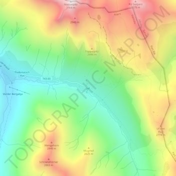
Name: Juf topographic map, elevation, terrain.
Location: Juf, Avers, Viamala, Grisons, 7448, Switzerland (46.42546 9.55970 46.46546 9.59970)
Average elevation: 8,100 ft
Minimum elevation: 6,490 ft
Maximum elevation: 10,328 ft
Thank you for supporting this site ❤️
Make a donation
Make a donation
Gear up for your next adventure:
As an Amazon Associate, this site earns from qualifying purchases at no extra cost to you.