
Santuario Histórico Bosque de Pómac topographic map
Interactive map
Click on the map to display elevation.
About this map
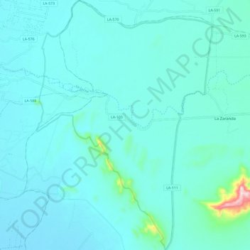
Name: Santuario Histórico Bosque de Pómac topographic map, elevation, terrain.
Average elevation: 249 ft
Minimum elevation: 128 ft
Maximum elevation: 1,325 ft
Other topographic maps
Click on a map to view its topography, its elevation and its terrain.
Santa Clara
Perú > Lambayeque > Pítipo
Santa Clara, Pítipo, Ferreñafe, Lambayeque, Perú
Average elevation: 299 ft
Provincia de Ferreñafe
Perú > Lambayeque > Pítipo
Provincia de Ferreñafe, Pítipo, Ferreñafe, Lambayeque, Perú
Average elevation: 2,008 ft
La Leche
Perú > Lambayeque > Pítipo
La Leche, Pítipo, Ferreñafe, Lambayeque, Perú
Average elevation: 253 ft
La Leche
Perú > Lambayeque > Pítipo
La Leche, Pítipo, Ferreñafe, Lambayeque, Perú
Average elevation: 1,263 ft