
Viña del Mar topographic map
Click on the map to display elevation.
About this map
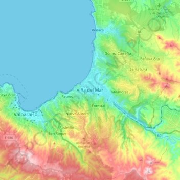
Name: Viña del Mar topographic map, elevation, terrain.
Average elevation: 518 ft
Minimum elevation: 0 ft
Maximum elevation: 1,739 ft
Other topographic maps
Click on a map to view its topography, its elevation and its terrain.
Placilla de Peñuelas
Chile > Valparaiso Region > Provincia de Valparaíso > Valparaíso
Average elevation: 1,161 ft
Playa Laguna Verde
Chile > Valparaiso Region > Provincia de Valparaíso > Valparaíso > Laguna Verde
Average elevation: 230 ft
Placilla de Peñuelas
Chile > Valparaiso Region > Provincia de Valparaíso > Valparaíso
Average elevation: 1,161 ft