
Thank you for supporting this site ❤️
Make a donation
Make a donation
Gear up for your next adventure:
As an Amazon Associate, this site earns from qualifying purchases at no extra cost to you.
Ain Regada topographic map
Click on the map to display elevation.
Thank you for supporting this site ❤️
Make a donation
Make a donation
Gear up for your next adventure:
As an Amazon Associate, this site earns from qualifying purchases at no extra cost to you.
About this map
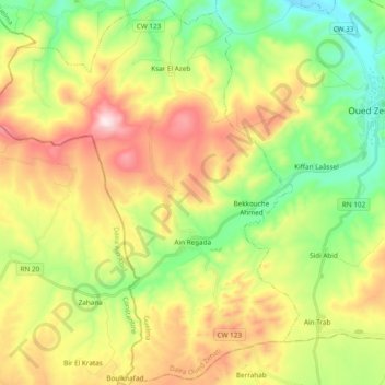
Name: Ain Regada topographic map, elevation, terrain.
Location: Ain Regada, Oued Zenati District, Guelma, 24000, Algeria (36.20316 6.96518 36.35699 7.12766)
Average elevation: 2,674 ft
Minimum elevation: 1,903 ft
Maximum elevation: 3,776 ft
Thank you for supporting this site ❤️
Make a donation
Make a donation
Gear up for your next adventure:
As an Amazon Associate, this site earns from qualifying purchases at no extra cost to you.
Other topographic maps
Click on a map to view its topography, its elevation and its terrain.
Bordj Sabat
Algeria > Guelma > Oued Zenati District > Bordj Sabat > Bordj Sabat
Average elevation: 2,182 ft