
Ouled Brahem topographic map
Interactive map
Click on the map to display elevation.
About this map
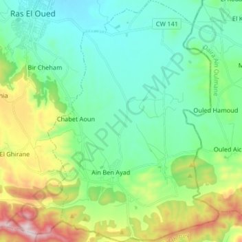
Name: Ouled Brahem topographic map, elevation, terrain.
Location: Ouled Brahem, Daïra Ras El Oued, Bordj Bou Arreridj, Algérie (35.84293 5.03995 35.95035 5.13403)
Average elevation: 4,144 ft
Minimum elevation: 3,468 ft
Maximum elevation: 6,027 ft
Other topographic maps
Click on a map to view its topography, its elevation and its terrain.
Demnet es Sef
Algérie > Bordj Bou Arreridj > Daïra Ras El Oued > Ouled Brahem
Demnet es Sef, Ouled Brahem, Daïra Ras El Oued, Bordj Bou Arreridj, Algérie
Average elevation: 4,255 ft