
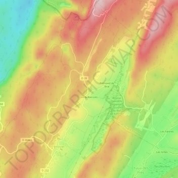
Les Belbenoits topographic map
Interactive map
Click on the map to display elevation.
About this map
Name: Les Belbenoits topographic map, elevation, terrain.
Average elevation: 3,035 ft
Minimum elevation: 2,497 ft
Maximum elevation: 3,468 ft
Other topographic maps
Click on a map to view its topography, its elevation and its terrain.
Prénovel
France > Bourgogne-Franche-Comté > Jura > Nanchez
Prénovel, Nanchez, Saint-Claude, Jura, Bourgogne-Franche-Comté, France métropolitaine, 39150, France
Average elevation: 3,005 ft
Prénovel de Bise
France > Bourgogne-Franche-Comté > Jura > Nanchez > Prénovel de Bise
Prénovel de Bise, Prénovel, Nanchez, Saint-Claude, Jura, Bourgogne-Franche-Comté, France métropolitaine, 39150, France
Average elevation: 3,045 ft
Les Belbenoits
France > Bourgogne-Franche-Comté > Jura > Nanchez
Les Belbenoits, Prénovel, Nanchez, Saint-Claude, Jura, Bourgogne-Franche-Comté, France métropolitaine, 39150, France
Average elevation: 3,031 ft