
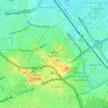
Aastha Kunj Park topographic map
Interactive map
Click on the map to display elevation.
About this map
Name: Aastha Kunj Park topographic map, elevation, terrain.
Average elevation: 732 ft
Minimum elevation: 686 ft
Maximum elevation: 807 ft
Other topographic maps
Click on a map to view its topography, its elevation and its terrain.
Greater Kailash II
India > Delhi > Kalkaji Tehsil
Greater Kailash II, Alaknanda, Kalkaji Tehsil, South East Delhi District, Delhi, India
Average elevation: 764 ft
DDA Flats
India > Delhi > Kalkaji Tehsil
DDA Flats, Kalkaji, Kalkaji Tehsil, South East Delhi District, Delhi, India
Average elevation: 764 ft
Chittaranjan Park
India > Delhi > Kalkaji Tehsil
Chittaranjan Park, Kalkaji Tehsil, South East Delhi, Delhi, India
Average elevation: 761 ft
Nehru Place
India > Delhi > Kalkaji Tehsil
Nehru Place, Kalkaji Tehsil, South East Delhi, Delhi, India
Average elevation: 745 ft