
Make a donation
Gear up for your next adventure:
As an Amazon Associate, this site earns from qualifying purchases at no extra cost to you.
Bakhtiari topographic map
Click on the map to display elevation.
Make a donation
Gear up for your next adventure:
As an Amazon Associate, this site earns from qualifying purchases at no extra cost to you.
About this map
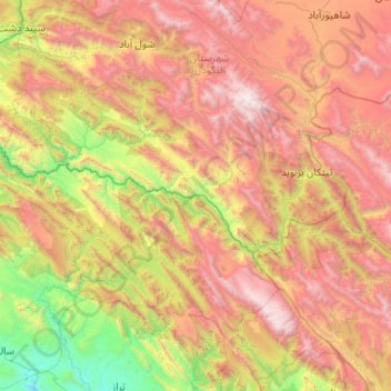
Name: Bakhtiari topographic map, elevation, terrain.
Location: Bakhtiari, Khuzestan Province, Iran (32.71621 48.75809 32.96964 49.79822)
Average elevation: 6,178 ft
Minimum elevation: 1,093 ft
Maximum elevation: 13,196 ft
Make a donation
Gear up for your next adventure:
As an Amazon Associate, this site earns from qualifying purchases at no extra cost to you.
Other topographic maps
Click on a map to view its topography, its elevation and its terrain.
Make a donation
Gear up for your next adventure:
As an Amazon Associate, this site earns from qualifying purchases at no extra cost to you.
Baran
Iran > Khuzestan Province > Izeh County > دهستان سوسن غربی > دوپوک انصاری
Average elevation: 2,887 ft
Make a donation
Gear up for your next adventure:
As an Amazon Associate, this site earns from qualifying purchases at no extra cost to you.