
Eede topographic map
Interactive map
Click on the map to display elevation.
About this map
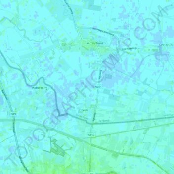
Name: Eede topographic map, elevation, terrain.
Location: Eede, Sluis, Seeland, Niederlande (51.24150 3.41787 51.27074 3.52804)
Average elevation: 7 ft
Minimum elevation: -10 ft
Maximum elevation: 23 ft
Other topographic maps
Click on a map to view its topography, its elevation and its terrain.
Aardenburg
Niederlande > Seeland > Sluis
Aardenburg, Sluis, Seeland, Niederlande
Average elevation: 3 ft
IJzendijke
Niederlande > Seeland > Sluis
IJzendijke, Sluis, Seeland, Niederlande
Average elevation: 0 ft
Retranchement
Niederlande > Seeland > Sluis
Retranchement, Sluis, Seeland, Niederlande
Average elevation: 3 ft