
Solakkadu topographic map
Interactive map
Click on the map to display elevation.
About this map
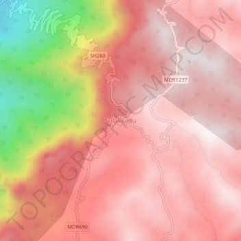
Name: Solakkadu topographic map, elevation, terrain.
Location: Solakkadu, KOLLI HILLS, Namakkal District, Tamil Nadu, India (11.28992 78.32917 11.32992 78.36917)
Average elevation: 3,497 ft
Minimum elevation: 1,050 ft
Maximum elevation: 4,478 ft
Other topographic maps
Click on a map to view its topography, its elevation and its terrain.
Valavanthinadu
India > Tamil Nadu > KOLLI HILLS
Valavanthinadu, KOLLI HILLS, Namakkal District, Tamil Nadu, India
Average elevation: 3,711 ft