
Saint-Jean Eudes Saint-Gilles topographic map
Interactive map
Click on the map to display elevation.
About this map
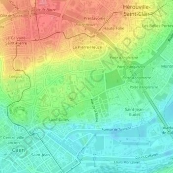
Name: Saint-Jean Eudes Saint-Gilles topographic map, elevation, terrain.
Average elevation: 105 ft
Minimum elevation: -7 ft
Maximum elevation: 249 ft
Other topographic maps
Click on a map to view its topography, its elevation and its terrain.
Bureau de vote n°03.1
Bureau de vote n°03.1, Rue Saint-Ouen, Le Bon Sauveur, Saint-Ouen, Caen, Calvados, Normandie, France métropolitaine, 14000, France
Average elevation: 75 ft
Saint-Jean
Saint-Jean, Caen, Calvados, Normandie, France métropolitaine, 14000, France
Average elevation: 66 ft
Bas-Venoix - Prairie
Bas-Venoix - Prairie, Caen, Calvados, Normandie, France métropolitaine, 14000, France
Average elevation: 66 ft
Centre Ancien
Centre Ancien, Caen, Calvados, Normandie, France métropolitaine, 14000, France
Average elevation: 75 ft
Sainte-Thérèse Demi-lune
Sainte-Thérèse Demi-lune, Caen, Calvados, Normandie, France métropolitaine, 14000, France
Average elevation: 72 ft