
Kulpenberg topographic map
Interactive map
Click on the map to display elevation.
About this map
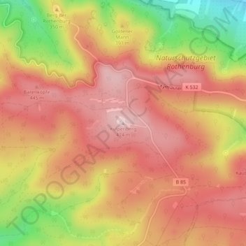
Name: Kulpenberg topographic map, elevation, terrain.
Average elevation: 1,224 ft
Minimum elevation: 640 ft
Maximum elevation: 1,558 ft
Other topographic maps
Click on a map to view its topography, its elevation and its terrain.
Kyffhäuserland
Deutschland > Thüringen > Kyffhäuserland
Kyffhäuserland, Kyffhäuserkreis, Thüringen, 99707, Deutschland
Average elevation: 876 ft
Rottleben
Deutschland > Thüringen > Kyffhäuserland
Rottleben, Kyffhäuserland, Kyffhäuserkreis, Thüringen, 99707, Deutschland
Average elevation: 630 ft
Badra
Deutschland > Thüringen > Kyffhäuserland
Badra, Kyffhäuserland, Kyffhäuserkreis, Thüringen, Deutschland
Average elevation: 791 ft