
Behla topographic map
Interactive map
Click on the map to display elevation.
About this map
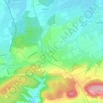
Name: Behla topographic map, elevation, terrain.
Average elevation: 2,425 ft
Minimum elevation: 2,241 ft
Maximum elevation: 2,835 ft
Other topographic maps
Click on a map to view its topography, its elevation and its terrain.
Fürstenberg
Deutschland > Baden-Württemberg > Schwarzwald-Baar-Kreis > Hüfingen
Fürstenberg, Hüfingen, Verwaltungsverband Donaueschingen, Schwarzwald-Baar-Kreis, Baden-Württemberg, Deutschland
Average elevation: 2,500 ft