
Sea Pines topographic map
Click on the map to display elevation.
About this map
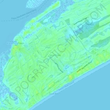
Name: Sea Pines topographic map, elevation, terrain.
Average elevation: 13 ft
Minimum elevation: -10 ft
Maximum elevation: 43 ft
Beaufort County trails, hiking, mountain biking, running and outdoor activities
Other topographic maps
Click on a map to view its topography, its elevation and its terrain.
Jenkins Island
United States > South Carolina > Beaufort County > Hilton Head Island
Average elevation: 3 ft
Pocosin
United States > South Carolina > Beaufort County > Hilton Head Island
Average elevation: 13 ft