
Namakwa District Municipality topographic map
Interactive map
Click on the map to display elevation.
About this map
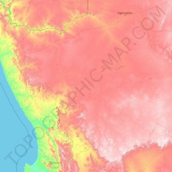
Name: Namakwa District Municipality topographic map, elevation, terrain.
Location: Namakwa District Municipality, Northern Cape, South Africa (-32.94500 16.45194 -28.03276 22.20628)
Average elevation: 2,602 ft
Minimum elevation: 0 ft
Maximum elevation: 6,250 ft
Other topographic maps
Click on a map to view its topography, its elevation and its terrain.
Aggeneys
South Africa > Northern Cape > Namakwa District Municipality > Khâi-Ma Local Municipality > Aggeneys
Aggeneys, Khâi-Ma Local Municipality, Namakwa District Municipality, Northern Cape, South Africa
Average elevation: 2,900 ft
Port Nolloth
South Africa > Northern Cape > Namakwa District Municipality > Richtersveld Local Municipality
Port Nolloth, Richtersveld Local Municipality, Namakwa District Municipality, Northern Cape, South Africa
Average elevation: 39 ft