Geolocate

Bay City topographic map

Click on the map to display elevation.

About this map
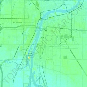
Name: Bay City topographic map, elevation, terrain.

Location: Bay City, Bay County, Michigan, 48708, United States (43.53867 -83.91616 43.62383 -83.84528)

Average elevation: 594 ft

Minimum elevation: 568 ft

Maximum elevation: 663 ft

Bay County trails, hiking, mountain biking, running and outdoor activities

Other topographic maps

Click on a map to view its topography, its elevation and its terrain.
Kawkawlin

United States > Michigan > Bay County

Average elevation: 594 ft

Gear up for your next adventure:

🚑Emergency Bivvies - Heat-reflective sleeping bags for survival situations
❄️Traction Cleats - Prevent slips on icy trails during winter hikes
🦶Carbon Trekking Poles - Reduce knee impact on steep descents with ultra-light poles
🖼️Topo Map Wall Art - Decorative topographic prints of famous peaks and regions
🛡️Bear Spray Outdoor - Protection in bear country hikes

As an Amazon Associate, this site earns from qualifying purchases at no extra cost to you.