
Coldwater topographic map
Interactive map
Click on the map to display elevation.
About this map
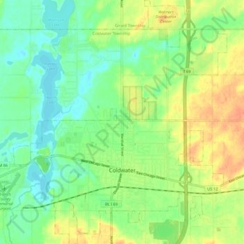
Name: Coldwater topographic map, elevation, terrain.
Location: Coldwater, Branch County, Michigan, United States of America (41.91658 -85.04757 41.99473 -84.95543)
Average elevation: 971 ft
Minimum elevation: 915 ft
Maximum elevation: 1,043 ft
Coldwater is at 41°56′25″N 85°00′02″W / 41.94028°N 85.00056°W / 41.94028; -85.00056. The ZIP code is 49036 and the FIPS place code is 17020. The elevation is 969 feet (295 m) above sea level. The City of Coldwater is entirely surrounded by the Township of Coldwater.