
Mbala topographic map
Interactive map
Click on the map to display elevation.
About this map
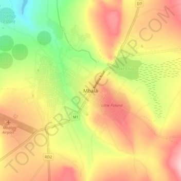
Name: Mbala topographic map, elevation, terrain.
Location: Mbala, Mbala District, Northern Province, Zambia (-8.88561 31.33092 -8.80561 31.41092)
Average elevation: 5,354 ft
Minimum elevation: 5,023 ft
Maximum elevation: 5,636 ft
The town is at the edge of the plateau covering most of Zambia, at an elevation of 1670 m, about 900 m higher than Lake Tanganyika, which comes within 22 km (straight-line distance). The escarpment above the lake is the end of the Albertine Rift, the western branch of the East Africa Rift, and the Mbala area experiences occasional earth tremors. It is also said that the tiny but picturesque Lake Chila within the town experiences inexplicable drying out, and sudden flooding from underground springs, but this may be just a legend.
Other topographic maps
Click on a map to view its topography, its elevation and its terrain.
Makoko
Makoko, Kaputa District, Northern Province, Zambia
Average elevation: 3,425 ft
Kasama
Kasama, Kasama District, Northern Province, Zambia
Average elevation: 4,354 ft
Kumbula Island
Zambia > Northern Province > Mpulungu
Kumbula Island, Mpulungu, Mpulungu District, Northern Province, Zambia
Average elevation: 2,546 ft