
St Stephen topographic map
Interactive map
Click on the map to display elevation.
About this map
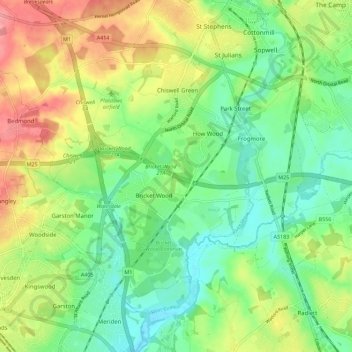
Name: St Stephen topographic map, elevation, terrain.
Average elevation: 295 ft
Minimum elevation: 180 ft
Maximum elevation: 472 ft
Other topographic maps
Click on a map to view its topography, its elevation and its terrain.
Hatching Green
United Kingdom > England > St Albans > Hatching Green
Hatching Green, St Albans, Hertfordshire, East of England, England, AL5 2JS, United Kingdom
Average elevation: 390 ft
River Ver
United Kingdom > England > St Albans
River Ver, St Albans, Hertfordshire, East of England, England, AL1 2HE, United Kingdom
Average elevation: 279 ft
St Michael
United Kingdom > England > St Albans
St Michael, St Albans, Hertfordshire, East of England, England, United Kingdom
Average elevation: 387 ft