
Mai Châu District topographic map
Interactive map
Click on the map to display elevation.
About this map
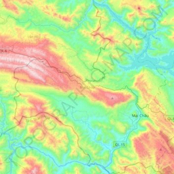
Name: Mai Châu District topographic map, elevation, terrain.
Location: Mai Châu District, Hoà Bình province, Vietnam (20.55722 104.83648 20.87561 105.15879)
Average elevation: 1,801 ft
Minimum elevation: 243 ft
Maximum elevation: 4,934 ft
Mai Châu is a mountainous region located in Hòa Bình Province, approximately 135 km from Hanoi and 65 km from Hòa Bình. The east of Mai Châu borders Đà Bắc and Tân Lạc districts, the west and the south border Quan Hóa district of Thanh Hóa province, and the north borders Vân Hồ district of Sơn La province. Mai Châu's terrain is quite complex, divided by slits, streams and high mountains. According to the topographic characteristics, Mai Châu can be divided into two distinct areas: the low region (relatively flat terrain with fertile soil) and the high region (with many high and rugged mountain ranges).
Other topographic maps
Click on a map to view its topography, its elevation and its terrain.
Yên Thủy District
Yên Thủy District, Hoà Bình province, Vietnam
Average elevation: 410 ft
Bản Lác
Vietnam > Hoa Binh province > Mai Châu District > Chiềng Châu
Bản Lác, Chiềng Châu, Mai Châu District, Hoà Bình province, Vietnam
Average elevation: 915 ft
Tân Lạc District
Tân Lạc District, Hoà Bình province, Vietnam
Average elevation: 1,365 ft