Geolocate

Dundas topographic map

Click on the map to display elevation.

Dundas

According to the United States Census Bureau, the city has a total area of 1.92 square miles (4.97 km2), all land. The Cannon River passes through the center of town. The latitude of Dundas is 44.429N. The longitude is 93.204W. Dundas' elevation is 932 feet above sea level.

Wikipedia (CC-BY-SA 3.0)

About this map

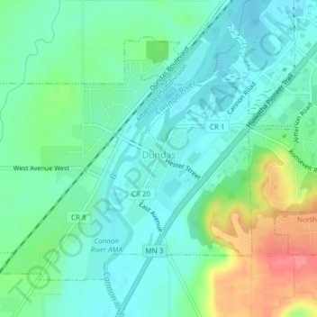
Name: Dundas topographic map, elevation, terrain.

Location: Dundas, Rice County, Minnesota, United States (44.41871 -93.22127 44.43951 -93.17334)

Average elevation: 978 ft

Minimum elevation: 906 ft

Maximum elevation: 1,155 ft

Rice County trails, hiking, mountain biking, running and outdoor activities

Other topographic maps

Click on a map to view its topography, its elevation and its terrain.

Comus

United States > Minnesota > Rice County > Bridgewater Township

Average elevation: 1,020 ft

Veseli

United States > Minnesota > Rice County

Average elevation: 1,073 ft

Northfield

United States > Minnesota > Rice County

Average elevation: 984 ft

Heath Creek

United States > Minnesota > Rice County > Northfield

Average elevation: 958 ft

Gear up for your next adventure:

🥩Freeze-Dried Meals - Nutritious and lightweight food for remote expeditions
🔭Telescopic Hiking Pole - Adjustable pole for hiking stability
🪑Ultralight Camp Chairs - Portable seating for resting after a long day of mapping
🍳Camping Cook Set - Complete cookware for outdoor meals
🧭Pro Hiking Compasses - High-accuracy liquid-filled compasses for topographic orientation

As an Amazon Associate, this site earns from qualifying purchases at no extra cost to you.