
Lac Come topographic map
Interactive map
Click on the map to display elevation.
About this map
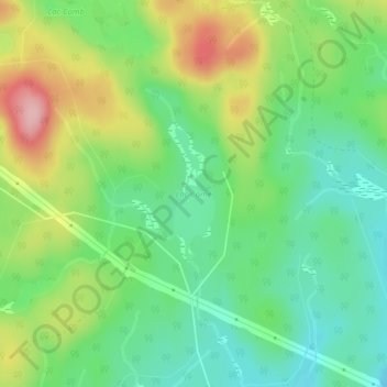
Name: Lac Come topographic map, elevation, terrain.
Location: Lac Come, Lac-Matawin, Matawinie, Lanaudière, Québec, Canada (46.94216 -74.36045 46.95178 -74.35605)
Average elevation: 1,801 ft
Minimum elevation: 1,601 ft
Maximum elevation: 2,142 ft
Other topographic maps
Click on a map to view its topography, its elevation and its terrain.
Lac Jens
Canada > Québec > Matawinie > Lac-Matawin
Lac Jens, Lac-Matawin, Matawinie, Lanaudière, Québec, Canada
Average elevation: 1,778 ft
Lac Cub
Canada > Québec > Matawinie > Lac-Matawin
Lac Cub, Lac-Matawin, Matawinie, Lanaudière, Québec, Canada
Average elevation: 1,801 ft
Lac Coppland
Canada > Québec > Matawinie > Lac-Matawin
Lac Coppland, Lac-Matawin, Matawinie, Lanaudière, Québec, Canada
Average elevation: 1,480 ft