
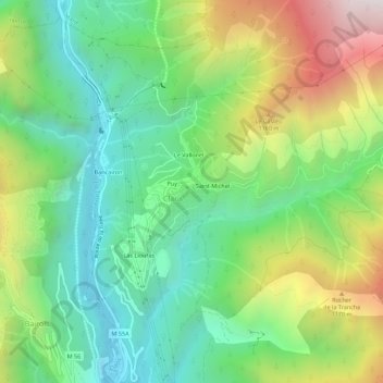
Le Barry topographic map
Interactive map
Click on the map to display elevation.
About this map
Name: Le Barry topographic map, elevation, terrain.
Average elevation: 2,448 ft
Minimum elevation: 922 ft
Maximum elevation: 5,243 ft
Other topographic maps
Click on a map to view its topography, its elevation and its terrain.
Pont de Clans
France > Provence-Alpes-Côte d'Azur > Alpes-Maritimes > Clans
Pont de Clans, Clans, Nice, Alpes-Maritimes, Provence-Alpes-Côte d'Azur, France métropolitaine, 06420, France
Average elevation: 2,238 ft
Saint-Michel
France > Provence-Alpes-Côte d'Azur > Alpes-Maritimes > Clans
Saint-Michel, Clans, Nice, Alpes-Maritimes, Provence-Alpes-Côte d'Azur, France métropolitaine, 06420, France
Average elevation: 2,510 ft