Geolocate

Cupang topographic map

Click on the map to display elevation.

About this map

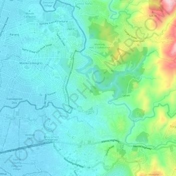
Name: Cupang topographic map, elevation, terrain.

Location: Cupang, Antipolo, Rizal, Calabarzon, 1870, Philippines (14.62424 121.12066 14.66019 121.17803)

Average elevation: 157 ft

Minimum elevation: 13 ft

Maximum elevation: 719 ft

Other topographic maps

Click on a map to view its topography, its elevation and its terrain.

Boso-boso River

Philippines > Rizal > Antipolo > San Joseph

Average elevation: 846 ft

Boso-boso River

Philippines > Rizal > Antipolo

Average elevation: 755 ft

Gear up for your next adventure:

🪶Camping Sleeping Pad - Comfortable sleeping pad for backpacking
🥩Freeze-Dried Meals - Nutritious and lightweight food for remote expeditions
🧥Waterproof Jacket for Hiking - Breathable and rugged rain jacket for outdoor excursions
🧥Men's Rain Shells - Premium waterproof and breathable jackets for mountain weather
📌Outdoor GPS Map App - Apps and devices for digital topographic navigation

As an Amazon Associate, this site earns from qualifying purchases at no extra cost to you.