
Hunau topographic map
Interactive map
Click on the map to display elevation.
About this map
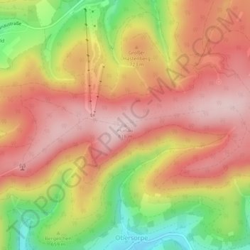
Name: Hunau topographic map, elevation, terrain.
Average elevation: 2,293 ft
Minimum elevation: 1,706 ft
Maximum elevation: 2,680 ft
Other topographic maps
Click on a map to view its topography, its elevation and its terrain.
Gellinghausen
Duitsland > Noordrijn-Westfalen > Schmallenberg > Gellinghausen
Gellinghausen, Schmallenberg, Hochsauerlandkreis, Noordrijn-Westfalen, Duitsland
Average elevation: 1,854 ft
Lengenbeck
Duitsland > Noordrijn-Westfalen > Schmallenberg > Lengenbeck
Lengenbeck, Schmallenberg, Hochsauerlandkreis, Noordrijn-Westfalen, Duitsland
Average elevation: 1,936 ft