
Maxillou topographic map
Interactive map
Click on the map to display elevation.
About this map
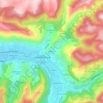
Name: Maxillou topographic map, elevation, terrain.
Average elevation: 1,542 ft
Minimum elevation: 1,027 ft
Maximum elevation: 2,169 ft
Other topographic maps
Click on a map to view its topography, its elevation and its terrain.
Les Combes
France > Occitanie > Aveyron > Saint-Affrique
Les Combes, Saint-Affrique, Millau, Aveyron, Occitanie, France métropolitaine, 12400, France
Average elevation: 1,539 ft
Vaxergues-le-Bas
France > Occitanie > Aveyron > Saint-Affrique
Vaxergues-le-Bas, Saint-Affrique, Millau, Aveyron, Occitanie, France métropolitaine, 12400, France
Average elevation: 1,450 ft
Maxillou
France > Occitanie > Aveyron > Saint-Affrique
Maxillou, Saint-Affrique, Millau, Aveyron, Occitanie, France métropolitaine, 12400, France
Average elevation: 1,667 ft
La Foux
France > Occitanie > Aveyron > Saint-Affrique
La Foux, Saint-Affrique, Millau, Aveyron, Occitanie, France métropolitaine, 12400, France
Average elevation: 1,860 ft
La Capelle
France > Occitanie > Aveyron > Saint-Affrique
La Capelle, Saint-Affrique, Millau, Aveyron, Occitanie, France métropolitaine, 12400, France
Average elevation: 1,509 ft