Geolocate

Isulan topographic map

Click on the map to display elevation.

About this map

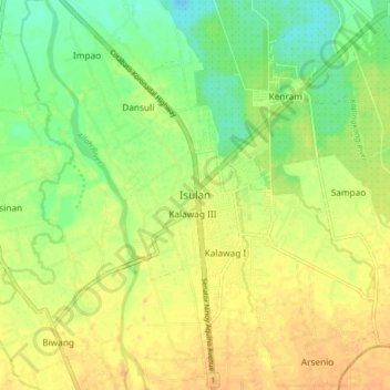
Name: Isulan topographic map, elevation, terrain.

Location: Isulan, Sultan Kudarat, 9805, Philippines (6.59409 124.55714 6.67409 124.63714)

Average elevation: 207 ft

Minimum elevation: 154 ft

Maximum elevation: 246 ft

Other topographic maps

Click on a map to view its topography, its elevation and its terrain.

Kabulnan River

Philippines > Sultan Kudarat

Average elevation: 1,939 ft

Gear up for your next adventure:

🔦Compact Flashlight - Reliable flashlight for emergencies
🎒Day Hiking Backpack - Lightweight backpack perfect for day trips and outdoor adventures
🕶️Glacier Sunglasses - Side shields to protect eyes from high-altitude snow glare
🧼Biodegradable Camping Soap - Eco‑friendly soap for outdoor hygiene
🧥Waterproof Jacket for Hiking - Breathable and rugged rain jacket for outdoor excursions

As an Amazon Associate, this site earns from qualifying purchases at no extra cost to you.