
Make a donation
Gear up for your next adventure:
As an Amazon Associate, this site earns from qualifying purchases at no extra cost to you.
Isla Cabeza de Caballo topographic map
Click on the map to display elevation.
Gear up for your next adventure:
As an Amazon Associate, this site earns from qualifying purchases at no extra cost to you.
About this map
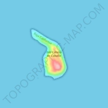
Name: Isla Cabeza de Caballo topographic map, elevation, terrain.
Average elevation: 16 ft
Minimum elevation: 0 ft
Maximum elevation: 525 ft
Make a donation
Gear up for your next adventure:
As an Amazon Associate, this site earns from qualifying purchases at no extra cost to you.
Other topographic maps
Click on a map to view its topography, its elevation and its terrain.
Make a donation
Gear up for your next adventure:
As an Amazon Associate, this site earns from qualifying purchases at no extra cost to you.
Ejido José María Morelos
México > Baja California > Municipio de San Quintín > Ejido Papalote
Average elevation: 59 ft
Playas de la Vicente Guerrero
México > Baja California > Municipio de San Quintín > Santa Fe
Average elevation: 89 ft
Make a donation
Gear up for your next adventure:
As an Amazon Associate, this site earns from qualifying purchases at no extra cost to you.