
Make a donation
Gear up for your next adventure:
As an Amazon Associate, this site earns from qualifying purchases at no extra cost to you.
Bad Salzuflen topographic map
Click on the map to display elevation.
Make a donation
Gear up for your next adventure:
As an Amazon Associate, this site earns from qualifying purchases at no extra cost to you.
Bad Salzuflen
Bad Salzuflen lies on the eastern edge of the Ravensberg Basin, at the confluence of the rivers Salze (Bega) with the Werre. In comparison to other North Lippe communities it is densely populated. The city centre is surrounded by districts with a village like feel to them and agricultural land. North east of the River Werre and Salze (Bega) runs a strand of the Lipper highlands runs through the largely wooded hills with elevations up to 250 meters in the city. The lowest point is on the border of the River Werre at Herford at about 70 meters. Since 2008, the city is part of the Teutoburg Forest Nature Park / Eggegebirge.
Make a donation
Gear up for your next adventure:
As an Amazon Associate, this site earns from qualifying purchases at no extra cost to you.
About this map
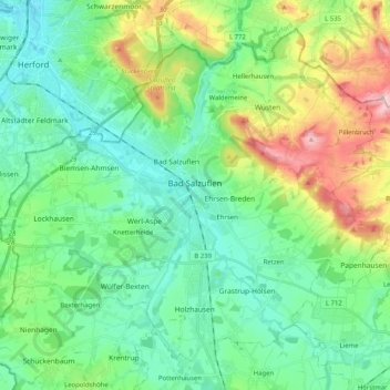
Name: Bad Salzuflen topographic map, elevation, terrain.
Location: Bad Salzuflen, Kreis Lippe, North Rhine-Westphalia, Germany (52.01984 8.65323 52.12678 8.85657)
Average elevation: 394 ft
Minimum elevation: 197 ft
Maximum elevation: 912 ft
Make a donation
Gear up for your next adventure:
As an Amazon Associate, this site earns from qualifying purchases at no extra cost to you.