
Thank you for supporting this site ❤️
Make a donation
Make a donation
Gear up for your next adventure:
As an Amazon Associate, this site earns from qualifying purchases at no extra cost to you.
Bregenz topographic map
Click on the map to display elevation.
Thank you for supporting this site ❤️
Make a donation
Make a donation
Gear up for your next adventure:
As an Amazon Associate, this site earns from qualifying purchases at no extra cost to you.
About this map
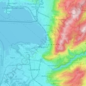
Name: Bregenz topographic map, elevation, terrain.
Location: Bregenz, Bezirk Bregenz, Vorarlberg, Austria (47.48002 9.65158 47.53466 9.80767)
Average elevation: 1,837 ft
Minimum elevation: 1,286 ft
Maximum elevation: 3,579 ft
Thank you for supporting this site ❤️
Make a donation
Make a donation
Gear up for your next adventure:
As an Amazon Associate, this site earns from qualifying purchases at no extra cost to you.